Friday 19 May 2017

Day 26: Lamorna Cove to Penzance

Weather: Mostly sunny with a cool breeze
Distance covered today: 10.0 km (6.2 mi)
Last night's B&B: Little Pengelly
% Complete: Cumulative distance:46.4 %: 471 km
Total Ascent/Total Descent: 223m/ 212m
GPS satellite track of today's route: Day 26(click!)


After yesterday’s energetic antics, I was pleased that today’s route was essentially a half day’s walk. My knees are now both in poor condition from the continuing pounding they have taken on the sharp ups and especially the downs of the trail. Still, today was very pleasant. After another episode of cove-hopping, I found myself in a lovely nature reserve called Kemyel Crease that had once been a series of tiny fields for growing bulbs such as daffodils and during the war, potatoes. Trees and shrubs provided shelter for the bulbs. Now the coniferous forest has taken over and it is unique in this area and provides a familiar landmark to passing vessels. The path gradually improved, becoming a track and then a road as I approached Mousehole (pronounced “Mowzul”). This is familiar territory. On my LEJOG expedition, I walked from Mousehole to Penzance and repeated the walk today with nostalgia, while it also allowed me to think tangentially about a problem that had occurred a day or two ago, that I have yet to mention.

On the edge of a cliff somewhere on the peninsula, I looked at my gadget to properly locate myself and was shocked to discover I was out at sea! More precisely, the detailed Ordnance Survey map which rolls along under the GPS positioning cursor had disappeared, to be replaced by a schematic and undetailed map provided by the gadget manufacturers. As a geeky cliff-hopper, this got my full attention instantly!

My first instinct was that I had inadvertently pressed a sequence of keys that had switched off the OS map, but this was not the case: the OS map had disappeared entirely. I sank to my knees on the cliff edge and started fiddling with the gadget’s innards. My concerns were not justified by my circumstances. I always take a paper copy of my route map with me, and on this trip I have two. In addition, I have an app on my mobile through which I download OS maps at the most detailed scale. I was also walking along a way-marked national trail on the coast of Britain. It would be close to impossible to get lost under these circumstances! On the other hand, I wouldn’t be your ambulatory geek if the failure of one of my gadgets wasn’t a matter of intense concern to me!

This crisis occurred in the midst of the much more serious digital crisis affecting the NHS and many other organisations across the world, which was all over the news, but which has affected us personally. The ransomware attack that paralysed major parts of the NHS caused my younger daughter’s operation on her broken collarbone to be postponed. They simply phoned her and told her not to come into the hospital until further notice. As it turned out, they finally managed to accommodate her and she had the necessary surgery yesterday, and is currently trying to cope with a painful recovery at home, having had to cancel a business trip to New York as a result of the delay.

The ransomware attack is not unexpected. I have personally observed many NHS practitioners still using Windows XP, though Microsoft stopped supporting XP with security patches back in 2014. In fact Microsoft stopped supporting XP’s successor system, Vista, earlier this year, causing me to have to buy a new PC. The popular computer press has been full of stories about ransomware over the past few months. The scary thing is that even if the cash-strapped NHS had upgraded their systems, this alone would have been no guarantee that an attack would have been prevented. This particular attack used a flaw in the operating system, but it is easy enough for ransomware to access files on hard drives through other mechanisms such as spam emails or dodgy internet sites.

Once it has infected a system, the software encrypts all files on the system and presents the user with a ransom note to undo the encryption. Even if you pay the ransom, there is no guarantee that the crooks will undo the encryption, and there is almost nothing a user can do to fix their system, short of formatting all their hard drives (deleting everything), reinstalling the operating system and restoring files from backup. The key point here though is that even if a user has been diligent in backing up all the data on their PC on a regular basis, if the backup disc is attached to the PC at the time of the infection, the backup will almost certainly be encrypted as well! It is essential therefore that backup discs are disconnected from the system at all times other than when the backup software itself is running! This is something I try to do myself, but have so far not managed to convince anyone else to do the same!

My own digital crisis on the cliffs was much more easily resolved. I discovered that the micro-SD card in my gadget that contains the data for the OS maps had become dislodged, presumably by an over-energetic leap from one rock to another with an undignified jar on landing. I reconnected everything and the system was perfectly restored. If only all our digital problems could be solved so easily!

By now I was being jolted out of my reverie by my arrival in Penzance well ahead of schedule. As planned, I headed straight for the Admiral Benbow pub to down a pint of Doom Bar ale in celebration of the completion of the second series of my South West Coast Path walks. The significance of the Admiral Benbow was that this was where I first had a pint of Doom Bar before setting out on LEJOG.

Tomorrow Veronica and I are off to a party with good friends before returning home. Thank you for accompanying me on this adventure and I hope to have your company again in about a year’s time!

Looking back at tranquil Lamorna Cove

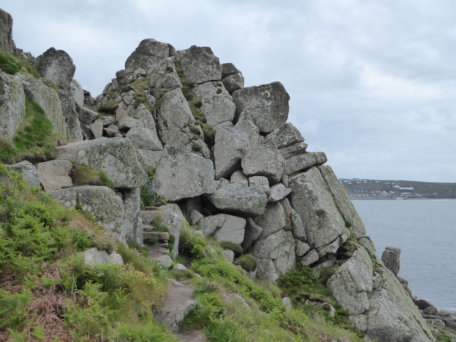
More difficult paths to cross the next headland, Carn-du

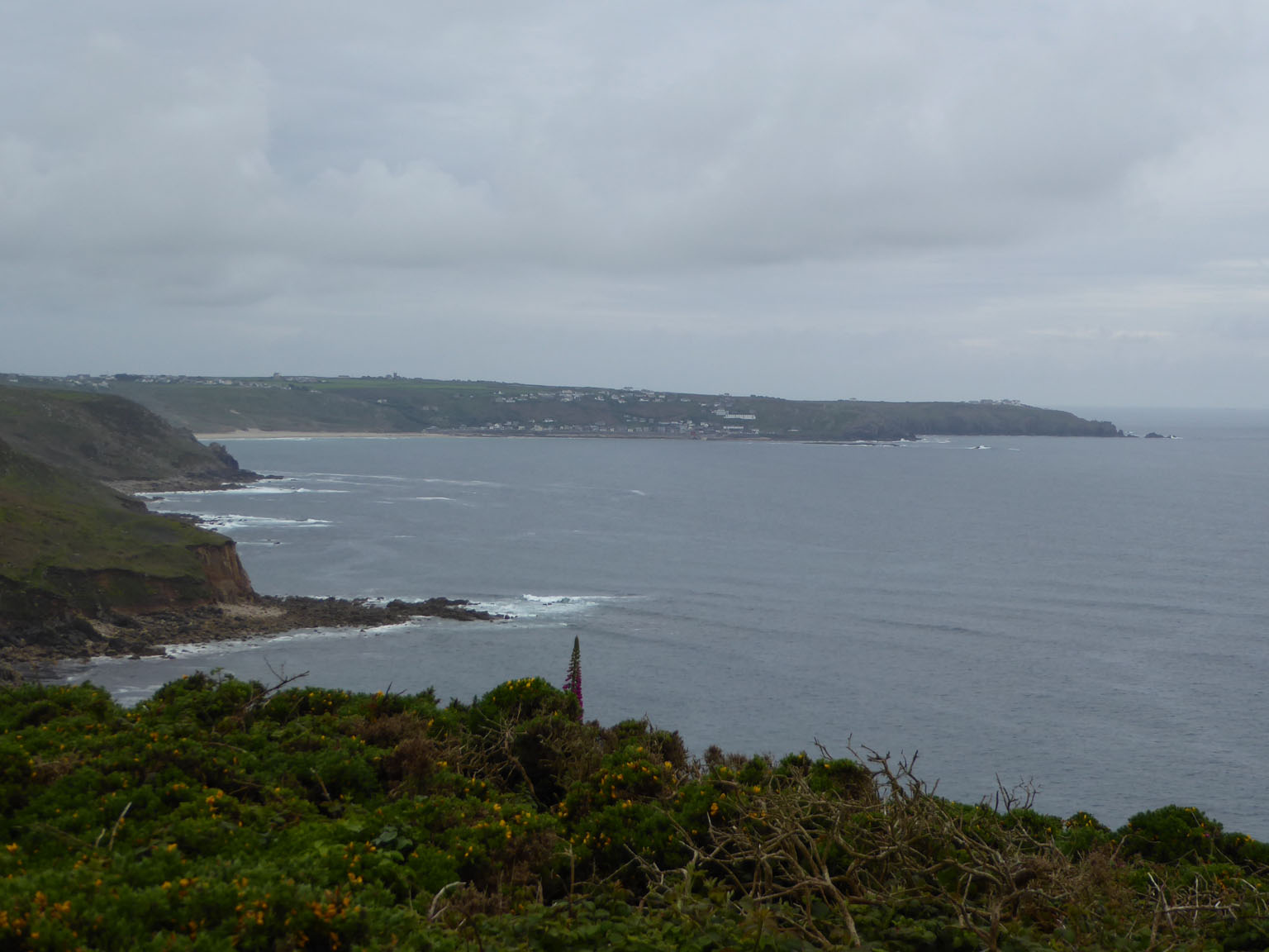
That's Lizard Point, way over the sea!

Once around the headland the path improved immeasurably

The lovely Kemyel Crease Nature Reserve

Kemyel's trees recede

Arum Lilies growing wild

The path gradually becomes a track

Out of the wild: the first houses of Mousehole appear

The lovely fishing harbour of Mousehole

St Michael's Mount over a bunch of Mousehole chimney pots under a gathering sky

Innovative allotments!

One doesn't normally expect political comment from graffiti! 

Newlyn comes into view

This read "Anyone who hasn't made a mistake hasn't tried to do anything"

The last acorn of this series of walks....

Newlyn today has the largest fishing industry in England

The bicycle track to Penzance

There appear to be many "Meaderies" in Cornwall

Penzance Harbour: next stop the Scilly Isles

The Admiral Benbow

My celebratory pint!!


Thursday 18 May 2017

Day 25: Land's End to Lamorna Cove

Weather: Sunny with a light, cool, following breeze. Perfect
Distance covered today: 18.4 km (11.4 mi)
Last night's B&B: Little Pengelly
% Complete: Cumulative distance: 45.5%: 461.0 km
Total Ascent/Total Descent: 806 m/ 866 m
GPS satellite track of today's route: Day 25(click!)


Tough day today, yet again, but mercifully it was to be executed in perfect weather. I was aware before the start that things might be a little unpredictable, because the geography looked difficult. Researching the route suggested that from Land’s End there were any number of major “freeways” along the cliffs to provide round circuits for those visiting the resort. Over time, and as the distance from the resort increased, so the number of people and the condition of the path declined. It soon became clear that it was to be another day of extreme ups and downs and I might as well get used to it!

Interestingly,  I was now meeting people that I had met on previous stretches of the path on a regular basis and we were treating each other as old friends. I noticed though that the regulars were almost always foreigners. It seems that the English do not wish to walk these long distance paths. They are perfectly happy to do day trips which involve circular walks, but doing the whole thing, or even parts of the trail: no, best left to foreigners. This is hard to justify, because the beauty of the scenery is simply majestic and it seems to me to be unique, though I am not really in a position to judge.

Unexpectedly, after the crowds had thinned out to an almost lonely hike, gradually they started building again. I was approaching the phenomenon of the Minack Theatre, an extraordinary, open air theatre created by Rowena Cade. She was as extraordinary as the theatre she created. With just a few helpers, she built this amazing construction on the edge of a sheer cliff. The view from the bleachers down to the stage and to the sea beyond is simply unparalleled. The site regularly puts on Shakespearian productions, as well as more contemporary plays, though for me, in that inspirational setting, I would love to hear music. What a place to perform Pink Floyd’s “The Wall”!

Minack is located in Porthcurno which is also significant as the location of an historic submarine communications cable station. In the late nineteenth century, the remote beach at Porthcurno became internationally famous as the British termination of early submarine telegraph cables, the first of which was landed in 1870, part of an early international link stretching all the way from the UK to India. In the Inter-War years, the Porthcurno cable office operated as many as 14 cables, for a time becoming the largest submarine cable station in the world, with the capacity to receive and transmit up to two million words a day.

I had intended to visit the museum, but was surprised to find it wasn’t even signed off the Coast Path and I missed it completely. This suggests to me that its significance is a little undervalued in today’s public imagination.

For me, larger problems lay ahead. Beyond Porthcurno the path became increasingly demanding and I was having difficulty keeping to my agreed time schedule with Veronica. I was crossing stepping stones at Penberth Cove, when a female voice called me for assistance. She had been driving down into the cove when a tyre had punctured and she had no idea what to do. Obviously, I tried to assist to change the tyre, but after half an hour of valuable time, discovered that her tyre lock key didn’t fit her second-hand car tyre wheel. There was no mobile connection in the cove and she was desperate! I had a deadline to meet Veronica and was already significantly late! We phaffed around for a while without reward, until some local residents arrived and suggested that mobile access to the AA might be available in a certain location, further up the cliffs. Feeling awful, I used this as my excuse for withdrawal and set about dashing off to meet Veronica.

The condition of the path steadily deteriorated until it was scarcely a path at all; just a clamber over the rocks on the edge of the cliff. I was trying to balance being careful with moving as swiftly as possible so that I could meet Veronica as close to the agreed schedule as possible; an impossible dilemma!

Fortunately, Veronica met some youngsters at our agreed meeting point who assured her that the way was indeed much more difficult than had been anticipated and that she should allow me some leeway. Quite exhausted, I met her an hour later than planned at the quay in Lamorna Cove.  Seeing her, completely in control of her emotions, being rational and logical, was as reassuring as it could possibly be.  I fell asleep in the car on the way back to our accommodation.

How very comforting!

Land's End recedes

Another arch

Magnificent colours!

Who knows what these are? I'll have to research them at leisure!

First beach on the South Coast

I have been guarding this place for millennia and I still feel involved!

The beach at Porthcurno

The marvellous amphitheatre at Minack

Looking up from the stage

Incredible lady...

Beautiful Porthcurno Beach

These guys seem as if they have been blown backwards by the prevailing southwesters!

A pony for Veronica to go with her donkey!

Stepping stones to a flat tyre

The offended vehicle

A skyscraper on the horizon, probably from China

Beautifully rounded granite

Back to the forest

Arum Lillies!!

Stream to sea

Is this a path????

The geology changes. Granite gives way to sandstone

The lighthouse at Tater-du

????

How to cross this?? Veronica is waiting!


Wednesday 17 May 2017

Day 24: Pendeen to Land's End

Weather: Sunny with a light breeze
Distance covered today: 18.4 km (11.4 mi)
Last night's B&B: Little Pengelly
% Complete: Cumulative distance: 43.6 %:  442.6 km
Total Ascent/Total Descent: 609 m/ 615 m
GPS satellite track of today's route: Day 24(click!)


We were in the car half-way to the drop-off point. The weather was miserable; Veronica was using full fog lamps to see through the mist and the forecast was for continuing rain and high winds. I was feeling just as miserable, with a head cold the severity of which I have no words to express and I was tired after two difficult days on the trail. Veronica suddenly suggested that I take the day off….

What a revolutionary idea!

After all, in six years of long-distance walking, I have never spontaneously deviated from the plan! Neither illness nor injury has been any excuse. Now though, the circumstances are very different. We are staying in the same place for all of my walks around the end of the peninsula, so accommodation arrangements aren’t an issue, nor is baggage transfer. I had also allowed myself a spare day at the end of the trip for rest and recuperation, so why not use that day now when the weather was bad and I was feeling sick and tired? Much to Veronica’s amazement, I agreed. She turned the car around, dropped me at the B&B to mope about in solitude and went about her business in the higher, esoteric world of beautiful gardens and artworks of which we Neanderthals understand little.

It was a splendid Idea! I dosed myself, resisted the whiskey bottle, went to sleep and when I awoke I watched grand stuff on the internet. Essentially I rejuvenated! By this morning I was rearing to go and off I went like a spring hare with a point to prove!

And what a fascinating day it was! For a start the going was easier, but much more interestingly, I was moving through some of the most historically relevant areas of the Cornish mining industry. Early in the walk I passed Geevor Mine, which closed down as recently as 1990. From the coast path it looked like an operational complex, but in fact it is being run by a few retired miners as a heritage museum, complete with underground tours. The bulk of the miners have apparently emigrated. A little further along the coast and connected to Geevor is the Beam Engine at Levant Mine. It is the last surviving steam engine in Cornwall, operated for tourists by the National Trust. Originally these high pressure steam engines were used to pump water out of the mines, and also to move men and materials. Again, tours are available but time didn’t allow.

I was though, fascinated to discover something of the finances of the mining industry. Apparently, investors were called "adventurers". For instance for the Levant Mine, in 1820 twenty adventurers paid a sum of £20 each for a share (£400 in total, around £35,000 today). They could be called upon to invest more, but in the case of Levant that proved unnecessary. In 1821, a rich copper lode was cut and the company started to pay dividends. Over the next twenty years, these amounted to £12,500 per share. Every two months a shareholders meeting was held which involved a really good dinner with ale, wine and spirits. It was said that some investors bought shares just so they could attend the dinners!

More hauntingly, one of the chimneys near Levant still displays a blackened rim which was the effect of the arsenic works below. Arsenic was produced as a by-product of calcining tin concentrates to drive off impurities. Men and boys scraped off the greyish-white arsenic crystals by hand on the inside of these chimneys and in the 50 years from 1854, Levant Mine alone produced nearly 5,000 tons of crude arsenic. Arsenic was used for dying clothes, making lead shot, coloured wallpaper and as medicine and pesticide. The men working these mines received almost no protective clothing other than cotton-wool nose- plugs, handkerchiefs and clay rubbed into exposed skin.

Further down the coast I almost missed what is apparently one of the most photographed relics of the Cornish mining industry at Botallack. I was talking to a group of walkers from North Carolina and if their leader hadn’t called my attention to it, I would have missed it. I was able to regain my poise by explaining to the group that the inclined shafts from this mine angled out beneath the sea and in storms the miners could hear boulders on the sea bed moving about under the influence of the waves. Ultimately the sea broke into the workings.

A little further down the coast, I reached Cape Cornwall. Until the first Ordnance Survey 200 years ago, this was believed to be the most westerly point of the UK, with a monument to celebrate the fact, but the OS of course then decreed that Land’s End deserves that dubious accolade. I say dubious, because Land’s End has, if anything, descended further as a tasteless commercial emporium since I was last there six years ago. No doubt it serves the trippers needs and they certainly flock to it. I had hoped to meet Veronica there in a glorious re-enactment of my departure for John O’Groats from there six years ago.

As it happened we met, had a Cornish ice-cream and went back to the B&B. The most I can say is that on the famous milepost, the distance to John O’Groats is still the same; 874 miles, some 328 miles less than it took me to reach the same goal, by my devious path.

Despite the tat, I couldn’t help feeling real nostalgia. I don’t think I will ever forget how challenged I felt on that morning, wondering why I was embarking on such a useless enterprise, and whether I had any chance of succeeding.

Well, I did, and it was worth it…..

The Lighthouse at Pendeen Watch

Geevor Mine: closed as recently as 1990

Multi-coloured ore stains on the rocks

The early workings at Geevor and Levant Mines


The blackened chimney of the arsenic recovery plant

The Bean Engine at Levant Mine

Back to the cliffs! 


The engine houses at the inclined Crowns Shafts at Botallack. These shafts went under the sea

Industrial archaeology everywhere


Cape Cornwall

A donkey for Veronica! 

Land's End in the distance

Steep cliffs with mine shafts everywhere. Care needed!

Even steeper cliffs!

How to get across this lot? Patience and care...

At last a beach! In fact the last beach on the North Coast at Sennen Cove 

Land's End lighthouse

The Land's End commercial complex on the hill

King Arthur and Shaun the Sheep........

A reunion!